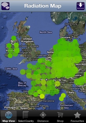
Ever wanted to know the natural radiation where you live? Or compare the current radiation levels in Japan with those in your home town? Then this app is what you are looking for. "EcoData: Radiation" displays radioactivity levels of monitoring stations from all over the world in near real time. Select stations of interest from a map, browse station lists, explore the stations in your vicinity, or create and manage your own radiation monitoring station list. With over 2900 monitoring stations in 22 countries, this app beats all other available radiation apps in terms of "price per country" and content. And our country database is still growing...
"EcoData: Radiation" features radiation data from the following countries/providers:
✔ JAPAN (Institute for Information Design Japan, ~370 monitoring stations including over 100 near Fukushima)
✔ USA (Environmental Protection Agency, 122 monitoring stations)
✔ USA (Los Alamos National Laboratory, 11 monitoring stations)
✔ USA (Desert Research Institute, Nevada System of Higher Education, 29 monitoring stations)
✔ GERMANY (Bundesamt für Strahlenschutz, ~1750 monitoring stations)
✔ IRELAND (Radiological Protection Institute of Ireland, 13 monitoring stations)
✔ CHINA (Hong Kong, Hong Kong Observatory, 10 monitoring stations)
✔ CHINA (Taiwan, Taiwan Radiation Monitoring Center, Taiwan, 33 monitoring stations)
✔ SLOVENIA (Slovenian Nuclear Safety Administration, 76 monitoring stations)
✔ FINLAND (Radiation and Nuclear Safety Authority Finland, ~250 monitoring stations)
✔ AUSTRALIA (Australian Nuclear Science and Technology Organisation, 1 station)
✔ HUNGARY (National Directorate General for Disaster Management, 112 monitoring stations)
✔ FRANCE incl. overseas territories and some neighboring countries (Institut de Radioprotection et de Sûreté Nucléaire, ~165 monitoring stations, DATA CURRENTLY NOT UPDATED, SEE NOTICE BELOW)
Many features, including:
✔ Twitter, Facebook and Email integration. Tweet, Post or Send Radiation values and plots. You can even Tweet and Email screenshots from the Radiation Map.
✔ Near real time "live" radiation data for all countries (exceptions: data from EPA and the Hong Kong Observatory are only accessible via weblinks)
✔ Customized radiation graphs, with super color coding, so you can quickly identify current and previous radiation levels (InApp purchase)
✔ Radiation maps for all countries including basic statistics, such as maximum and minimum radioactivity levels (InApp purchase)
✔ Color coded map view annotations and station lists with latest radiation levels (available for most networks)
✔ Radiation monitoring station info and radiation levels directly on the map
✔ Monitoring stations sorted by distance from your current location
✔ A favorites list
✔ Information on radioactivity, learn about what is radiation, units of radiation, Gray (Gy), Sievert (Sv), how radiation is measured, types of radiation, exposure rates, sources of radiation, equivalent dose, understanding gamma dose rate, gamma count, beta counts, absorbed dose, background radiation and more.
The "live" data is displayed using an intuitive color-coding scheme that allows easy comparison of radiation levels both for neighboring stations as well as for stations separated by hundreds or thousands of miles.
If you like EcoData: Radiation then be sure to review and rate the app and Tell-A-Friend...
Notes:
➔ This is not a fake Geiger Counter app
➔ The radiation data is from real radiation monitoring stations
➔ All radiation levels are directly shown on the map view (exceptions: data from EPA and the Hong Kong Observatory are only accessible via weblinks)
➔ The French data has not been updated since 12/09/2011. The website, where this information has been made available for the public in the past does not exist any more. The French provider is planning to resume the service in 2012.
➔ iOS 4.2.x and above required


